Malawi
Where is it?

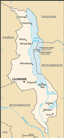
Country Map
Country Flag
Geography
|
Continent:
|
Africa |
|
Area:
|
118,480 sq km OR 45,745 sq mi |
|
Coastline:
|
0 km OR 0 mi |
|
Elevation extremes:
|
lowest point: 37 m OR 121 ft highest point: 3002 m OR 9,849 ft |
Population
|
Population:
|
17,215,232 (2010) |
|
Population growth rate:
|
3.11% (2010) |
|
Population density:
|
145 per sq km OR 376 per sq mi |
|
Urban vs Rural Population:
|
Urban: 16.30% Rural: 83.70% |
|
Life Expectancy:
|
51.7 (2010) |
|
Infant Mortality:
|
81.04 (2010) |
|
Birth Rate:
|
39.8 per 1000 (2010) |
|
Death Rate:
|
9 per 1000 (2010) |
|
Overall Literacy:
|
74.80% (2010) |
|
Male Literacy:
|
81.10% (2010) |
|
Female Literacy:
|
68.50% (2010) |
Government
|
Capital:
|
Lilongwe |
|
Official Language(s):
|
English Chichewa |
Economy
|
GDP Per Capita:
|
$360 |
|
Currency:
|
Kwacha |
Top
 Back to Country List